Yesterday I drove with my bike out to Battle Ground, Washington to continue testing out the route that my friend Andrew had designed for us to follow on the 180km "Dart" that we plan to ride in March. I'd done a portion of the route last week, but wanted to get a little bit further along this time. We have to submit the route for approval by March 9, and I wanted to have as much of it pre-ridden as I could by then. The section I'd chosen for Saturday's ride was from Battle Ground to Kelso, by way of LaCenter, Woodland, Kalama and Carrolls. The stretch from LaCenter to Kelso would all be new terrain for me, and I had no idea what to expect.
It was sunny, breezy and cold - 34 degrees - when I pulled into the parking lot of the Safeway in Battle Ground, my chosen start point. I had chemical hand and toe warmers with me, and decided to deploy them. I also pulled out the fleece ear warmers and wool helmet liner. I was quickly ready to ride and set off, after first checking that I had (1) locked the car, and (2) not locked my keys in it (I checked on that 4 times - because like all the cyclists I know, I am just a LITTLE bit OCD . . . )
The route from Battle Ground to LaCenter starts on a busy highway, but quickly gave over to farmland. Near Daybreak Park I turned onto the route followed by the Vancouver Bike Club's annual "Ride Around Clark County." Nice, narrow country roads with no shoulders that change their names every time they curve . . . just the kind of thing to give an anal OCD cyclist working on a cue sheet fits. Except for one steep sharp pitch on JA Moore Road, and another steep roller on Lockwood Creek, the route was very flat. I wish I could say the same for the section from LaCenter to Kelso.
I should have known there would be trouble when I was mapping the route out on Friday night and saw that I would be spending a good bit of time on "Green Mountain Road." Keyword: MOUNTAIN. It turned out to be over three miles of very steep uphill. I think that my top speed was about 5 mph, but I spent most of the time down between 3-4 mph. I had to stop THREE times because I was going so slowly that maintaining verticality was a challenge. I kept thinking, "Boy, I'd better get some awesome descent as pay-off for this!" But alas, it was not to be. The road back down (Lane Road - I kept wondering if it had a counterpart called "Road Lane" somewhere) was treacherous; very steep, with tight turns and a fine film of sand and gravel over the entire road surface. I, who rarely use my brakes on descents if I can help it, rode my brakes down the whole way. Toward the end, there is a section where the pavement was gone, and there was just hard pack dirt and gravel. It was only about 3 ft. wide, though, and passable. Whew! The rest of the route had more gentle slopes, but I was climbing for most of the segment. I spent most of my time paralleling I-5 on the old Pacific Highway (aka Cloverdale, 1st Street, Meeker, Cottonwood, Old 99 S, Kelso Drive, etc. etc. depending on what town I was in . . .). The roads were for the most part good, but had little to no shoulder. Traffic was light, though, and most of the drivers polites. I was chased by FOUR dogs at various times - one of them a large and scary Rottweiler . . . that was not so much fun.
It's just over 38 miles from Battle Ground to Kelso, and it took me 3 hours and 10 minutes to cover it, riding as hard as I could and stopping as little as possible (I stopped only to make notes for the cue sheet and to rest on Green Mountain Road). By the time I got to my designated end point, the 3 Rivers Safeway in Kelso, I was so very ready for my PB and banana sammich.
Coming home, I took Cloverdale up to Green Mountain instead of Lane. That was a mistake. The climb was even steeper than coming up the other side, and over two miles longer. At the top, the snow was deep on the ground and the sand was deep on the road. I wasn't able to really open up until I was almost to the bottom. Even so, at that point I still sustained speeds of 38 mph + the entire way down, with a top speed of 45 mph.
I stopped for another snack in LaCenter. I was virtuous and passed up the Girl Scout cookies being sold (I could have eaten an entire box and then later regretted it), and instead had some salty crackers, an orange and some more Gatorade. Back at the Battle Ground Safeway I got some very tasty chocolate soy milk and a Diet Coke, and finished off my salty crackers.
When I got home, Greg had all the ingredients set out for pizza. I quickly assembled it and shortly thereafter sat down to an eclectic but satisfying meal of a baked potato, a baked yam, two slices of pizza and salad. Greg ate the rest of the pizza, but I got his crusts . . .
Sunday, February 24, 2008
Wednesday, February 20, 2008

Saturday, February 16, 2008
Three Days, 228 miles. Not Bad For Mid-February . . .
Just when I was beginning to think I would never be able to take my fenders off the bike, the Presidents' Day weekend not only promised to be remarkably warm, sunny and dry, it followed THROUGH on that promise (unlike any actual PRESIDENT) . . . and so, like any good American, I took full advantage of the unexpected bonus, and rode my increasingly bony a** off.
Saturday, I met some friends down in Newberg to ride another 200 km (124.1 miles, give or take) "permanent" route, so as to get my February ride in for the RUSA R12 award. We chose to ride the "Three Prairies" permanent route, a relatively flat jaunt that starts and ends in Newberg (and goes back there in the middle of the ride as well!). My friends Lynne and Sal, who are both also trying for an R12, signed up to ride along with me. Our friend Andrew also tagged along but because he did not register for the ride in time, he could not get credit toward an R12. More importantly, because he was not registered, he would not be allowed to help any of us if we encountered mechanical trouble. We could help HIM, apparently (I told him 'Don't count on it. . . .") but not vice versa.
We arranged to leave Newberg at 8:00 AM - a relatively late start for a 200K, but Sal was driving up from Salem, and he likes to start at "civilized" times. I didn't mind - it meant we would be starting in daylight. Always a plus. I was up at 5:30, out the door by 6:30, but then spent 5 minutes scraping ice of my car. Hmmm. Good thing I had both hand and toe warmers packed in my bag. By mid-day, the temperature had reached 52 degrees, and I could discard the digit warmers.

I arrived in Newberg with plenty of time for a tasty soy cocoa at the Coffee Cottage, our designated meeting/start place. As we headed out, the temperature was 34 degrees, and there was frost on the ground in places. The 3 Prairies ride is just that - it loops through French, Red and Howell Prairies, with stops in Dallas and Mt. Angel, in addition with a stop in Newberg in the middle. In other words, we saw the good people at the Coffee Cottage at 7:30 AM, 1:54 PM, and 7:20 PM. More importantly, we ate their tasty baked goods at 7:30 AM, 1:54 PM, and 7:20 PM. The brownie at lunch was particularly delicious (of course, after I've been riding for 70 miles, I find that most food is delicious).
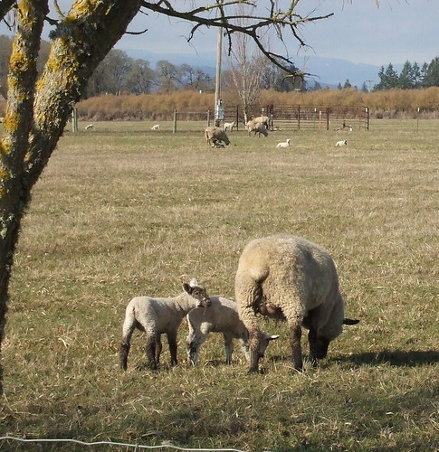
The ride itself is advertised as "amazingly flat." It nevertheless has about 3000 feet of elevation gain, but it is all in the form of long, steady grades - no rollers or sharp pitches (which, sadly, also means no screaming descents). Apart from the wine-tasting traffic hell that is the stretch between Newberg and Dayton, the roads were mostly low-traffic and rural (i.e. chip seal). LOTS of baby animals, mostly lambs.
At one point we startled a Coopers hawk that had just settled down to a nice lunch - apparently some large rodent, judging from the limp four-legged form hanging from the hawk's talons as it took off to find a less popular cafe.
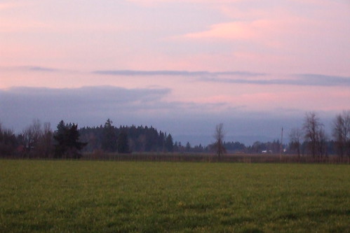
Compared to Lynne's and my January 200 km ride, this one was a piece of cake - we reached all the controls well ahead of schedule (so I was not turning into an OCD mess) and we only had to ride in the dark for about an hour. I was not all that disappointed that we were still riding at sundown, because the sunset was spectacular!
We finished the ride at 7:30. Lynne's husband had called to tell her that he was cooking her a steak for dinner - for my part, I was looking forward to making the world's largest burrito. I pretty much just emptied the contents of my refrigerator into a tortilla. Some black beans, some left over baked tofu, some leftover filling from stuffed mushrooms (mushrooms, onions, garlic, TVP and spices), half an avocado, tomatoes, lettuce, lots of salsa, some plain yogurt . . . by the time I was done filling it, I couldn't fold the tortilla properly, so I made a tin foil cone to keep it from exploding.
Sunday, it was even sunnier and warmer than Saturday had been. Lynne rode over to my house, and we rode out to North Portland to meet our friend Beth for a short ride out to Smith & Bybee Lakes and then back to North Portland through St. Johns. This was most definitely a more leisurely ride - neither Lynne nor I felt like pushing it much after Saturday's adventure, and I had a 70+ mile ride planned for Monday . . . so we just meandered our way out along the Columbia Slough past Portland Meadows, PIR and the golf course to the lakes and on past on the Marine Drive bike path. At the end of the bike path we decided to skip riding into Kelly Point Park and just waved at it as we rode on past on our way to St. John's and the very fine Anna Bananas for some very tasty cheese and bread and, of course, bananas! I dropped Lynne off at a MAX stop (she didn't feel like riding up and over Sylvan again - I can't blame her) and I headed home to spend some quality time at the garden center with Greg. We needed to re-pot the two dwarf blueberries that live on our front porch before the terra cotta pots they had been in completely disintegrated. Since I can never leave the nursery without several enormous bags of compost, we also spent some quality time amending soil. By the time we were done, I was definitely ready for dinner - the first outdoor grilling of the year - piles of grilled vegetables on arugula and grilled lavash pizzas with green olives, fennel and dill . . . mmmmm
For Monday, I had set myself the task of "pre-riding" part of a route my friend Andrew had put together for us to use in a 12-hr "Dart" scheduled for March 22. We will start from Portland and end in Centralia, Washington, with stops in Vancouver, Battle Ground, Kelso and Winlock. I planned to check out the section from Portland to Battle Ground, because neither Andre nor I knew much about the roads that were in his map (he was drawing on other folks' knowledge in planning). I spent a few hours on Sunday night checking the cue sheet against gmaps, and finding that there were some very confusing parts to the directions. Mainly, all the streets seemed to have different names! Anyway, I finally figured it out (at least I hoped I had). By my calculations, the "pre-ride" would be about 40 miles, and then to get home would be another 30 or so, so I planned to leave as soon as it was light out.
As it was, I didn't make it out the door until about 7:45. By then, it was already noticeably warmer than it had been either Saturday or Sunday. But it was still cold enough that I needed leg warmers, thermal gloves and a jacket over my long-sleeved jersey. I threw some digit warmers into my bag, just in case . . .
Once I crossed over the Columbia River and into downtown Vancouver, it was noticeably chillier - there was frost on the ground and a cold wind. A hot cocoa helped me cope with that, though, and I never did need to pull out the chemical warmers. The route from Vancouver to Battle Ground was decidedly urban, but tolerable. I wouldn't want to ride some of those streets on a regular work day, though. I am guessing that they are pretty busy. On a holiday, however, they were not so bad.
All my map reading Sunday night helped me stay on track except for one section. Vancouver is one of those weird cities that has number streets AND numbered avenues, and they intersect each other in odd ways, so that if you have a number in mind but aren't sure if it is, for example "50th Street" or "50th Avenue," you can end up lost. Even if you DO have that part straight, you can still get lost because every once in a while the street numbers are out of sequence. Suffice it to say, I now know EXACTLY where to turn off St. John's Road to get to Salmon Creek.
Battle Ground is ugly. But once you get out of Battle Ground and head toward LaCenter, it gets downright pretty. It also gets hilly. And one street goes through 6 name changes. Grr. Again, however, the map reading [aid off, and I was able to figure out where to go. I reached LaCenter at lunch time, and thoroughly enjoyed my peanut butter and Ricemallow creme sammich. I also enjoyed pulling off the leg warmers and jacket for the first time this season. My knees didn't know what hit them.
Andrew's cue sheet would not help me get home from LaCenter, and I didn't want to just retrace what I had just done. Fortunately, I found a route on bikely.com that included the stretch from downtown LaCenter to downtown Vancouver (once downtown in the 'Couve, I could get home on my own). The bikely route was GREAT. It took me through some interesting rural parts of LaCenter and Ridgefield, and then through some Vancouver neighborhoods before dumping me out into downtown. Riding through the neighborhoods was interesting - there were some hidden bike pass-throughs to get from one block to the next. One "enterprising" jerk had transformed one of the bike pass-throughs into a second driveway, however.
The only part of the route that I did not like was where I had to ride on Hwy 99 for a while. That sucked. The road surface was bad, the bike lanes were full of tire-chewing debris, and the traffic was very heavy. Fortunately, that was only for about a mile, and then I peeled off onto the quieter neighborhoods just northwest of downtown. The best part of the route was climbing to the top of the "ridge" in Ridgefield, and then blasting straight downhill for what seemed like ages. The climb itself wasn't so bad, because the road I was on did it in stair-steps. Once I got to the top and turned around to see where I had come from, I was impressed by how high up I was.
Once I crossed back over the river to Oregon, I took my standard route home from Marine Drive. By the time I got to Ladd's Addition, my odometer showed 74.6 miles, so I rode arounf Ladd Circle a few times to ensure that it would read 75 by the time I got home. In the end, I could have left off one of those circuits, because the final readout in my back yard was 75.2.
Like I said, not bad for mid-February.

Saturday, I met some friends down in Newberg to ride another 200 km (124.1 miles, give or take) "permanent" route, so as to get my February ride in for the RUSA R12 award. We chose to ride the "Three Prairies" permanent route, a relatively flat jaunt that starts and ends in Newberg (and goes back there in the middle of the ride as well!). My friends Lynne and Sal, who are both also trying for an R12, signed up to ride along with me. Our friend Andrew also tagged along but because he did not register for the ride in time, he could not get credit toward an R12. More importantly, because he was not registered, he would not be allowed to help any of us if we encountered mechanical trouble. We could help HIM, apparently (I told him 'Don't count on it. . . .") but not vice versa.
We arranged to leave Newberg at 8:00 AM - a relatively late start for a 200K, but Sal was driving up from Salem, and he likes to start at "civilized" times. I didn't mind - it meant we would be starting in daylight. Always a plus. I was up at 5:30, out the door by 6:30, but then spent 5 minutes scraping ice of my car. Hmmm. Good thing I had both hand and toe warmers packed in my bag. By mid-day, the temperature had reached 52 degrees, and I could discard the digit warmers.

I arrived in Newberg with plenty of time for a tasty soy cocoa at the Coffee Cottage, our designated meeting/start place. As we headed out, the temperature was 34 degrees, and there was frost on the ground in places. The 3 Prairies ride is just that - it loops through French, Red and Howell Prairies, with stops in Dallas and Mt. Angel, in addition with a stop in Newberg in the middle. In other words, we saw the good people at the Coffee Cottage at 7:30 AM, 1:54 PM, and 7:20 PM. More importantly, we ate their tasty baked goods at 7:30 AM, 1:54 PM, and 7:20 PM. The brownie at lunch was particularly delicious (of course, after I've been riding for 70 miles, I find that most food is delicious).
The ride itself is advertised as "amazingly flat." It nevertheless has about 3000 feet of elevation gain, but it is all in the form of long, steady grades - no rollers or sharp pitches (which, sadly, also means no screaming descents). Apart from the wine-tasting traffic hell that is the stretch between Newberg and Dayton, the roads were mostly low-traffic and rural (i.e. chip seal). LOTS of baby animals, mostly lambs.
At one point we startled a Coopers hawk that had just settled down to a nice lunch - apparently some large rodent, judging from the limp four-legged form hanging from the hawk's talons as it took off to find a less popular cafe.
Compared to Lynne's and my January 200 km ride, this one was a piece of cake - we reached all the controls well ahead of schedule (so I was not turning into an OCD mess) and we only had to ride in the dark for about an hour. I was not all that disappointed that we were still riding at sundown, because the sunset was spectacular!
We finished the ride at 7:30. Lynne's husband had called to tell her that he was cooking her a steak for dinner - for my part, I was looking forward to making the world's largest burrito. I pretty much just emptied the contents of my refrigerator into a tortilla. Some black beans, some left over baked tofu, some leftover filling from stuffed mushrooms (mushrooms, onions, garlic, TVP and spices), half an avocado, tomatoes, lettuce, lots of salsa, some plain yogurt . . . by the time I was done filling it, I couldn't fold the tortilla properly, so I made a tin foil cone to keep it from exploding.
Sunday, it was even sunnier and warmer than Saturday had been. Lynne rode over to my house, and we rode out to North Portland to meet our friend Beth for a short ride out to Smith & Bybee Lakes and then back to North Portland through St. Johns. This was most definitely a more leisurely ride - neither Lynne nor I felt like pushing it much after Saturday's adventure, and I had a 70+ mile ride planned for Monday . . . so we just meandered our way out along the Columbia Slough past Portland Meadows, PIR and the golf course to the lakes and on past on the Marine Drive bike path. At the end of the bike path we decided to skip riding into Kelly Point Park and just waved at it as we rode on past on our way to St. John's and the very fine Anna Bananas for some very tasty cheese and bread and, of course, bananas! I dropped Lynne off at a MAX stop (she didn't feel like riding up and over Sylvan again - I can't blame her) and I headed home to spend some quality time at the garden center with Greg. We needed to re-pot the two dwarf blueberries that live on our front porch before the terra cotta pots they had been in completely disintegrated. Since I can never leave the nursery without several enormous bags of compost, we also spent some quality time amending soil. By the time we were done, I was definitely ready for dinner - the first outdoor grilling of the year - piles of grilled vegetables on arugula and grilled lavash pizzas with green olives, fennel and dill . . . mmmmm
For Monday, I had set myself the task of "pre-riding" part of a route my friend Andrew had put together for us to use in a 12-hr "Dart" scheduled for March 22. We will start from Portland and end in Centralia, Washington, with stops in Vancouver, Battle Ground, Kelso and Winlock. I planned to check out the section from Portland to Battle Ground, because neither Andre nor I knew much about the roads that were in his map (he was drawing on other folks' knowledge in planning). I spent a few hours on Sunday night checking the cue sheet against gmaps, and finding that there were some very confusing parts to the directions. Mainly, all the streets seemed to have different names! Anyway, I finally figured it out (at least I hoped I had). By my calculations, the "pre-ride" would be about 40 miles, and then to get home would be another 30 or so, so I planned to leave as soon as it was light out.
As it was, I didn't make it out the door until about 7:45. By then, it was already noticeably warmer than it had been either Saturday or Sunday. But it was still cold enough that I needed leg warmers, thermal gloves and a jacket over my long-sleeved jersey. I threw some digit warmers into my bag, just in case . . .
Once I crossed over the Columbia River and into downtown Vancouver, it was noticeably chillier - there was frost on the ground and a cold wind. A hot cocoa helped me cope with that, though, and I never did need to pull out the chemical warmers. The route from Vancouver to Battle Ground was decidedly urban, but tolerable. I wouldn't want to ride some of those streets on a regular work day, though. I am guessing that they are pretty busy. On a holiday, however, they were not so bad.
All my map reading Sunday night helped me stay on track except for one section. Vancouver is one of those weird cities that has number streets AND numbered avenues, and they intersect each other in odd ways, so that if you have a number in mind but aren't sure if it is, for example "50th Street" or "50th Avenue," you can end up lost. Even if you DO have that part straight, you can still get lost because every once in a while the street numbers are out of sequence. Suffice it to say, I now know EXACTLY where to turn off St. John's Road to get to Salmon Creek.
Battle Ground is ugly. But once you get out of Battle Ground and head toward LaCenter, it gets downright pretty. It also gets hilly. And one street goes through 6 name changes. Grr. Again, however, the map reading [aid off, and I was able to figure out where to go. I reached LaCenter at lunch time, and thoroughly enjoyed my peanut butter and Ricemallow creme sammich. I also enjoyed pulling off the leg warmers and jacket for the first time this season. My knees didn't know what hit them.
Andrew's cue sheet would not help me get home from LaCenter, and I didn't want to just retrace what I had just done. Fortunately, I found a route on bikely.com that included the stretch from downtown LaCenter to downtown Vancouver (once downtown in the 'Couve, I could get home on my own). The bikely route was GREAT. It took me through some interesting rural parts of LaCenter and Ridgefield, and then through some Vancouver neighborhoods before dumping me out into downtown. Riding through the neighborhoods was interesting - there were some hidden bike pass-throughs to get from one block to the next. One "enterprising" jerk had transformed one of the bike pass-throughs into a second driveway, however.
The only part of the route that I did not like was where I had to ride on Hwy 99 for a while. That sucked. The road surface was bad, the bike lanes were full of tire-chewing debris, and the traffic was very heavy. Fortunately, that was only for about a mile, and then I peeled off onto the quieter neighborhoods just northwest of downtown. The best part of the route was climbing to the top of the "ridge" in Ridgefield, and then blasting straight downhill for what seemed like ages. The climb itself wasn't so bad, because the road I was on did it in stair-steps. Once I got to the top and turned around to see where I had come from, I was impressed by how high up I was.
Once I crossed back over the river to Oregon, I took my standard route home from Marine Drive. By the time I got to Ladd's Addition, my odometer showed 74.6 miles, so I rode arounf Ladd Circle a few times to ensure that it would read 75 by the time I got home. In the end, I could have left off one of those circuits, because the final readout in my back yard was 75.2.
Like I said, not bad for mid-February.
Subscribe to:
Posts (Atom)