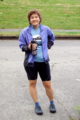
Such were the thoughts running through my head as I climbed the seven miles up Forest Road 58 to High Rock Summit, about one-quarter of the way into the workers' ride for the Oregon Randonneurs Timothy Lake 200. Neither Lynne nor I would be able to participate in the regularly scheduled ride on July 19, so when the ride organizer, Michael, sent out a call for volunteers, we jumped at the chance to do the workers' ride with him last Sunday. Michael normally rides faster than Lynne and I (MUCH faster) but he had just completed a very tough 1200 K ride a few days before, so we figured maybe we would be able to keep up with him. Famous last words.
There are three things to keep in mind about the Timothy Lake route. One: Michael designed it. Two: Michael likes hills. Three: The route is so spectacular that it is worth whatever temporary pain those hills might cause.
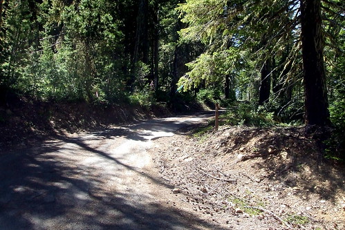
Where was I? Oh, yeah, I was climbing up to High Rock. Michael had advised us that the average grade for that seven mile stretch was 6%. What I had failed to take into account was the meaning of the term "average." What I should have asked for was the RANGE. Which, as it turns out, was 2% to 12%, with an awful lot of it at 7-8%. Hence my resort to my time-tested steep hill strategy of pedal, rest, pedal, rest, pedal, rest, ad infinitum . . .
But I have jumped too far ahead. Let's start from the very beginning (a very good place to start).
Unlike most of our Or Rando brevets, this one did not start in either Newberg or Forest Grove. Instead, the start is in Estacada, a small town in Clackamas County, on the edge of the Mt. Hood National Forest, about an hour's drive from Portland. This meant that even though we agreed that we would start riding at the very civilized hour of 8:00 AM, I nonetheless had to get up by 5:00 in order to be ready when Lynne came to pick me up at 6:00. Because she was driving in from almost-Beaverton, she had to get up even earlier. We told Michael we would pick him up at his house at about 6:45, so that we would get to the start with a few minutes to spare for traditional pre-ride faffing. For some reason I thought it would take me awhile to load my bike and gear into Lynne's van, and also take a while to drive over to Michael's house. As it was, Lynne arrived at my house a little early, and then she and I were at Michael's by 6:30. So we stood around on the street outside his house until it was time to knock on the door. Lynne drank her coffee (Tea? Something caffeinated in a thermal mug) while I stretched and played with my camera.
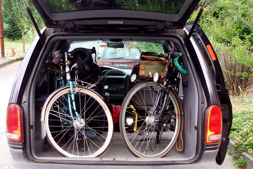
Once we managed to squeeze Michael's bike into the van, we were off. On the way to Estacada, Michael regaled us with stories of the 1200. Apparently it was hot. Very, very hot. The term "knee-busting" was also frequently invoked. Gee, it sounded like fun. Maybe next year, if they run it again. Then again, maybe not.
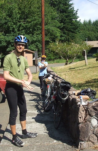
We arrived at the start point on Faraday Road with plenty of time to spare. After unloading the van, we engaged in a brief discussion about layering; at this point the sky was overcast, and there was the slightest of cool breezes. I was figuring it would clear up and heat up, so had not brought any arm or leg warmers. I had brought long fingered glove and a rain jacket, however, and did don those. Lynne went the full warmer route, but did not put on her wool cap. Michael realized he'd left his gloves at home. I mentioned I had an extra pair, but he pointed out that his hands were about 3 times large than mine . . .
Pre-ride faffing complete, we were on our way. The first five miles of the route are on Faraday Road, which runs along the Clackamas River, and used to be part of state highway 224. A few years back the highway was rerouted over the hill, however, and Faraday now is closed to all motor vehicles except those used by PGE to service its dams. Bicycles and pedestrians are more than welcome however. Very recently, the road was blocked even to cyclists by a very big rockslide, but that has since been repaired. The road is wide, flat, and beautiful.
After five miles, Faraday Road rejoins 224 and the road starts to tilt ever so slightly upwards. It is a very gentle grade, because it is still following the river. We stopped at Promontory Park for a bathroom break. There is a mini-mart there, and in retrospect I should have purchased a few more snacks to pack along. But at the time I figured I was fine - I had two bananas, two PB & banana sandwiches, two Clif bars, some peanuts, and a few "peanut flake" bars from the local Asian market. At the last minute before leaving home I had thought to throw an extra full water bottle into my pannier. That turned out to be a brilliant idea.
From Promontory Park we followed the river for about 20 miles to the Ripplebrook ranger station. There was a little climbing involved, but nothing that would make anyone with more than one gear nervous. We past a number of campgrounds and crossed over the Roaring River, which lives up to its name. We arrived at the station at about 10:00 and verified that there was indeed a little store there. Emphasis on "little." It was minimally stocked with some candy bars, chips, and ramen noodle cups. Camping basics. Water is readily available from a hose bib on the left hand side of the door, however, and there is a standard Forest Service pit toilet. Again, in retrospect I should have purchased a couple of candy bars or bags of chips. The sun was coming out, and we took a few minutes to slather on the sunscreen. Michael paid extra care to slather the lotion on his hands, which are so rarely ungloved.
From the Ripplebrook station we continued on for about half a mile to the junction with NFD 57, where we turned left away from the highway and into the woods. Traffic had been light, and now it was almost non-existent. The grade was still pretty gentle for the most part, but every once in while there was a bit of a pitch. It never seemed difficult though, so I was occasionally surprised when I glanced down at my incline indicator to see that it was registering 5 or 6%. Lynne asked if this was "the" climb. Michael responded with an evil laugh, "Noooooo, nooooo, heh heh heh heh . . ."
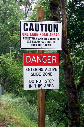
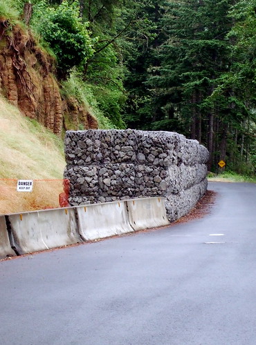
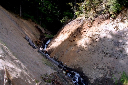
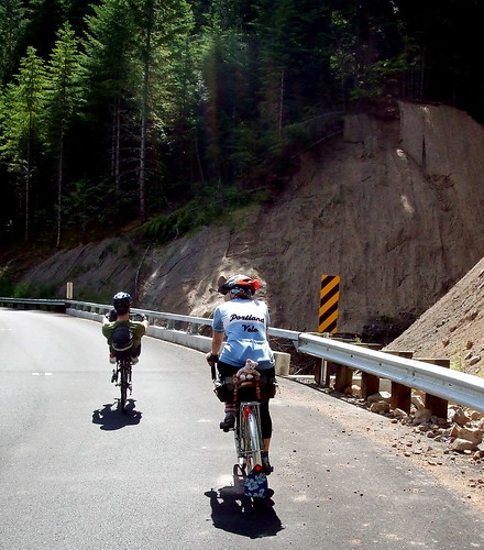
We had assumed that traffic was light because off a landslide that had blocked the road a few years back. The last we'd heard, it had not been cleared for cars to pass through, although it was easy enough to carry a bike around it. But there were SOME cars on the road, and they all seemed to be heading toward the section we'd thought was closed, and none of them seemed to be turning back. Hmmm. Eventually we reached the slide zone, and saw that it had finally been cleared. Dang. We'd been looking forward to having the road to ourselves again.
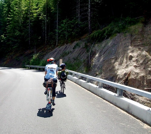
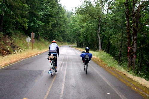
After about seven miles NFD 57 meets up with NFD 58. If we continued straight on NFD 57, we would reach Timothy Lake. We would also be riding uphill, on gravel. We turned onto NFD 58, instead, to begin the climb to High Rock Summit. It was still uphill, but it was paved. Wildflowers were out in force. Lilies, lupine, daisies, columbine, penstemon, trillium, beargrass, ocean spray, and big pink rhodies. I had plenty of opportunity to observe said blooms, because the road had canted fairly steeply up at this point, and I was rolling along very, very slowly. If Michael had not already figured out how much time he was going to be spending stopping and waiting for us to catch up with him, he certainly must have by this point.
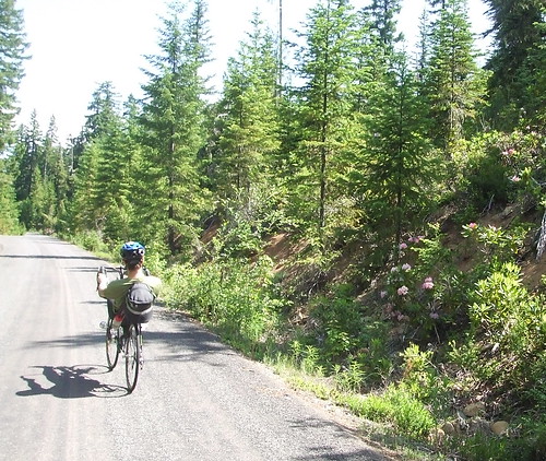
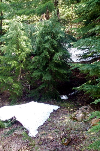
The sky had cleared completely by this point and it was warming up quickly. We were also gaining elevation, and the tree cover was thinning. I stopped and put on some more sunscreen. Up to this point I had been feeling pretty good about the climbing; I had been worried because the previous day I had done a very fast (for me) and hilly 88 mile club ride, and my quads were a little tired. But so far so good. What I had not anticipated, however, was the effect the altitude would soon have on me. My personal combination of anemia and low blood pressure make me particularly susceptible to hypoxia; I feel as weak at 4,000 feet as others might feel at 10,000 feet. High Rock tops out at just under 5,000 feet. That combined with the increasing steepness of the grade brings me back to where this post started -- pedal, pedal, pedal, rest. Pedal, pedal, pedal, rest. Another sign that we were gaining altitude? Snow. Not a lot of it, granted, but snow nonetheless.
Once we reached the top, it was definitely time for a lunch break. I'd already dipped into my food supplies and was out of bananas, but I inhaled a sandwich and two peanut flake bars in quick succession. Michael and Lynne also ate sandwiches and we chatted about the remaining route. Michael assured us that all the evil climbing was "pretty much" over. "Pretty much," we repeated skeptically. "Mostly." Yeah. Right.
The climbing was over for the moment, however. In the next 18 miles we would navigate a few rollers, and a couple of nice descents, to take us down about 1500 feet in elevation to the Historic Clackamas Lake Ranger Station on NFD 42 (aka Oregon Skyline). To me, the ranger station was notable for two things: (1) the visitors' center has an honest-to-gosh flush toilet (a National Forest rarity), and (2) when we arrived, it was the site of a meeting of the Zigzag Hotshots. I immediately flashed back to the summer of my junior year in high school, when I spent a few weeks in the Youth Conservation Corps, dodging rattlesnakes and clearing firebreaks alongside of (and lusting after) the Palomar Hotshots. Ah, youth. But I digress.
The visitors' center is an information control, so we spent a little time deciding what the question should be. Something obvious that can be seen in passing? Something obscure that would require riders to get down on their knees to find? Let's just say we chose something in between those extremes.
A few more snacks, another visit to the toilet (did I mention it flushes?), another sunscreen application, and we were ready to go. Our plan was to follow NFD 42/Oregon Skyline to Peavine Road, and then turn onto Peavine to shortcut to NFD 46. As we pulled out of the ranger station, Michael confessed that he had not ridden this portion of the route before and that in designing it he had relied on information from other riders who had assure him that it was paved and passable. "Here there be monsters," I joked.
It's about five miles from the ranger station to Peavine. Five miles uphill. Easily a match to the climb to High Rock. Two miles shorter, but with a couple of steep pitches. Here there be monsters, indeed.
Pedal, pedal, pedal, rest. Pedal, pedal, pedal, rest.
In addition to some more climbing, it was getting quite warm. Lynne stopped to strip off her leg warmers. Quote: "I'm dying here." Michael pointed out some power lines up ahead, and said that they marked the turn off to Peavine. Boy, they seemed far away. Michael pulled ahead of us, but I knew he would wait for us at the turn.
When I finally reached the intersection, Michael was indeed waiting, but with a rueful look. "I made a mistake," he said. "Uh-oh," I thought, "don't tell me that I just climbed that hill for nothing . . ." "What's up?" "Well, " said Michael, pointing to our right, "that's Peavine, and it's impassable." I looked and saw a potholed, cratered, barely-paved road that rose steeply to a hairpin turn around which I could not see. Oh, dear. I began to regret that whole "Here there be monsters" remark.
As I looked glumly up the road, Michael quickly explained that there might be a solution to our problem that did not involve turning around. He thought we might be able to simply continue straight on NFD 42 until it met up with NFD 46, and then continue on with the route as planned. It would add some distance, because Peavine was the shortcut to NFD 46, but we could cure that by cutting short the out-and-back to Bagby Hot Springs that came later in the ride. In retrospect, it was the best thing that could have happened, because shortly after Peavine we dropped into a descent for the ages. Eight miles of steep, smooth pavement with terrific sightlines and no technical corners. Even Lynne was able to ease up on her brakes for this one!
The one caution I would offer is that it is a one-lane road, and there can be traffic coming up hill, so staying to the right is recommended . . .
We were now back down to about 1500 feet in elevation and pretty much done with any intense climbing. From here on out it would be a combination of river grade flats and gentle rollers. I was looking forward to picking up the pace without working so hard.
Cue headwinds . . . .
Between the headwind, my altitude issues, my failure to pack enough food, and fatigue from the previous day's Portland Velo speed-fest, I was really beginning to struggle. By my calculations, we would not make it back to the Ripplebrook ranger station before its little store closed. Fortunately for me, Lynne had packed more than enough food and gave me a peanut butter granola bar from her stash. I a always happy when she comes on rides with me, but I was especially happy this time.
NFD 46 is the Clackamas River Road. It follows the river downstream and eventually turns into Highway 224, which we would follow back to the start. But first there was the matter of the out-and-back. Originally, the plan had been to turn off NFD 46 into NFD 63, the Collawash River Road. We would follow that to NFD 70, which is the turn-off to Bagby Hot Springs, and take NFD 70 all the way to the hot springs' parking lot. Because we'd added mileage by re-routing away from Peavine, we figured we only needed to go as far as the NFD 63/70 intersection before we turned back.
NFD 63 starts off with a very brief climb ("I don't remember this," said Michael), crosses over the Collawash River ("Okay, I remember this," said Michael), and then runs along the Collawash. Of all the roads we'd been on so far that day, this one had the worst pavement. It was not bad pavement; it just was not as good as we'd so far enjoyed. There were a lot of potholes, some fairly deep, that appeared to be caused by rocks falling from the steep cliffs to our right (heading out - to our left heading back in, of course). Each pothole was nicely outlined in orange, however, so they were easy to spot from a distance. Reaching the Bagby turn-off, we figured out an information control question and turned back for the home stretch.
By this point I was REALLY hungry. Starving. My stomach was singing little songs to me.
To make matters worse, all the water I had been drinking was making its presence known. By my calculations, we were less than 10 miles from Ripplebrook ranger station. The "store" would be closed, but the toilet would be open. That would take care of one problem, at least. Michael warned me that we would first have to tame a couple of pernicious rollers before we got to Ripplebrook; for once I think he overstated the case. Either that, or I was so anxious to get to the station that I was simply impervious to any more pain.
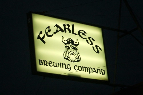
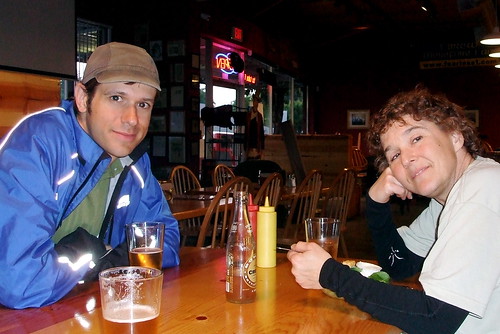
Back at Ripplebrook I made the necessary pit stop, slathered on a tad bit more sunscreen and girded up for the last leg. We were about 25 miles from where we parked the van, but had concluded that we needed to continue on into Estacada to make up some mileage. Michael suggested that we change the route's start/finish to the brewpub in town, to ensure that riders got the full benefit of 200 kilometers and to ensure that Michael got the benefit of beer while he waited to check riders in at the end.
From Ripplebrook to the end it is mostly downhill. Mostly. We were still being tormented by the headwind, however, and my calorie-deficit was taking its toll. What psychic energy I still had, I was focusing on the market at Promontory Park. "Please still be open. Please, please, please, still be open." I watched the mile markers slip away (slowly) and listened to my stomach rumble (loudly). Finally the turn off to the store hove into view. A short downhill into the parking lot and there it was. Michael was standing on the porch, a chocolate milk in his hand. Lynne and I hurried in and snagged the last two chocolate milks, a bag of Smart Food and a Rice Krispie treat. We sat on the steps, ate our snacks and discussed the next stage. We considered riding into Estacada and getting dinner at the brewpub before coming back for the van, but realized that we didn't have any bike locks. My snack had quieted my stomach's complaints for the time being, so we decided to ride into town, check the distance, come back for the van, and then go back for dinner and beer. Mmm, beer.
After a return trip down lovely Faraday Road to the van, we double-checked our mileage. Yup, we'd definitely have to change the start/finish to the brewpub. So into Estacada we went. On the way out the gate, Lynne noticed that it would close automatically at dusk. Another good reason to make the change. Some of the slower riders might get locked in for the night, otherwise.
We were all ready to be done at this point, so we rode quickly into town, stopped at the brewpub and noted the time and distance on our cards, and then rode just as quickly back and shoved the bikes into the van. Lynne had thought to bring a set of "apres ride" clothes, so she changed in the van while Michael and I called our respective homes to report our whereabouts (note: the parking lot may be the last place on the ride where you will have cell phone coverage). Then it was back to the brewpub, where just about everything on the menu is deep fried, except the beer. Yum.
2 comments:
We finished the ride! Your report struck enough fear into my newbie rando heart that I was prepared in both the hill-climbing-courage and the snacks departments. What you can never be prepared for is the unexpected glee of having a toilet that flushes in an otherwise flush-less landscape!
Hooray! And, yes, it is amazing how a simple thing like a flush toilet can bring joy to the heart of a randonneuse . . .
Post a Comment