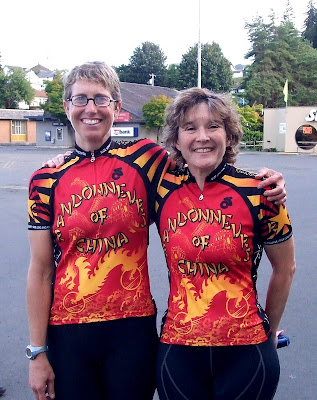
On Saturday last, my riding buddy Lynne and I decided to break in our new, matching, "Randonneurs of China" jerseys by taking them out on one of the Oregon Randonneurs' 200 km "permanent" brevets. This particular route went from Clatskanie, Oregon to Cape Disappointment in Washington and then back to Clatskanie by way of Astoria, Oregon (and the very, very long Astoria Bridge that connects WA and OR over the mouth of the Columbia River).

Clatskanie is little over 60 miles east of Portland, but the fastest way to get there is by heading north (!) to Washington and then crossing back over the Columbia by way of the Lewis & Clark Bridge out of Longview. Fortunately, we were doing this bit by car, because that Longview Bridge is a nightmare for cyclists.
The brevet started with a quick 9-mile sprint from Clatskanie to Westport, where we were to hop a ferry back (!) to Washington. We got a slightly late start, and then had to stop for some road construction (we got to be the "pilot" bikes when our traffic line was allowed to go), but we nevertheless made it to the ferry landing with time to spare, thanks to some marvelously smooth new pavement and little to no winds.

Road construction was the theme of the day, with the riding surface ranging from gloriously smooth new pavement on Oreogn Hwy 30 to agitating (literally) fresh chipseal (which appeared to have been laid over perfectly good smooth pavement) on Washington Hwy 4 to nerve-wracking grooved and scored pavement outside Ilwaco WA (the "Grooved Pavement Ahead" sign was for some mysterious reason placed AT THE END of said grooves . . .) on US 101 to the inches-deep loose gravel on the Stringtown Road detour from Hwy 101. Guess which one we finally decided to go around . . .

Apart from the ever-changing road surfaces, and occasional spurts of heavy traffic, the ride was a pleasant romp (if you call miles of endless climbing a romp) through various river valleys on our way to the coast and back. We passed through a few small towns, most of which, judging by the road names, were founded by Finns. Until we reached Highway 101 at the WA coast, there was very little in the way of motor vehicle traffic - that changed once we hit the coast. Lots of RVs made riding on the 101 somewhat challenging (it is a narrow highway with little in the way of a shoulder).
As usual, Lynne and I stopped to take lots of pictures.

The coastal stretch of the journey was lovely. Miles of salt marshes gave way to the Willapa Bay and then we hit the fishing town of Ilwaco. The fleet was in, but the sun had finally come out and we were able to shed our cold weather gear.

We reached the bridge to Astoria about 87.5 miles into the ride. The bridge is very long, with an elevated section on each end, and a long (really long) flat section close to the water in the middle.

The shoulders were narrow, but did not have as much debris as I had feared. Lots of dead birds, though. Fortunately, we had a tailwind to helps us up and over, and the motorists passing us were, for the most part, polite enough to give us room. There were quite a few periods of no motor vehicle traffic, so that we could actually stop worrying about getting hit and enjoy the view. Nevertheless, we were happy to get off the bridge and into Oregon - 3.5 miles later.

The ride from Astoria back to Clatskanie was pretty damn perfect - a blistering tailwind made the hills seem flat (well, all except that climb up to the Clatsop Summit - with three false summits, that one pretty much sucked, but the 2.5 mile descent at 36-40 mph made up for it).
128 miles
9088.5 feet elevation gain
9 hours, 12 minutes, 45 seconds in the saddle (and another 3 hours of general faffing around)
The rest of my pictures are here:
http://www.flickr.com/photos/cecilanne_r-s/sets/72157601403268327/

1 comment:
So *that's* where you've been!
Nice jerseys :-)
Post a Comment